By all accounts, Point Pinole Regional Shoreline is a park that probably shouldn’t exist. Prior to 1960, the land was owned by a company that manufactured gun powder and dynamite. This was followed by a brief time when Bethlehem Steel owned the point, before it was transferred to the East Bay park district in the 1970’s. Years of environmental clean-up and letting nature do its work have done the park a lot of good, and it has transformed into a lovely place to go for a hike and get great views of San Pablo Bay.
Driving up to it, you almost don’t expect to actually find a park amongst industrial warehouses and a county detention facility, but sure enough the sign for the park entrance appears when you least expect it. Park in the lot and follow the path to a pedestrian bridge over the train tracks. Here’s where the suggested hike that I took begins. Make an immediate left onto the Bay View Trail, and head downhill towards the water. Make a right when you reach the shoreline to continue on the Bay View Trail. At first, the trail doesn’t seem like the most scenic location. It follows the edge of San Pablo Bay and I think is near a landfill (it smelled like it). Bear with me, the trail gets better.
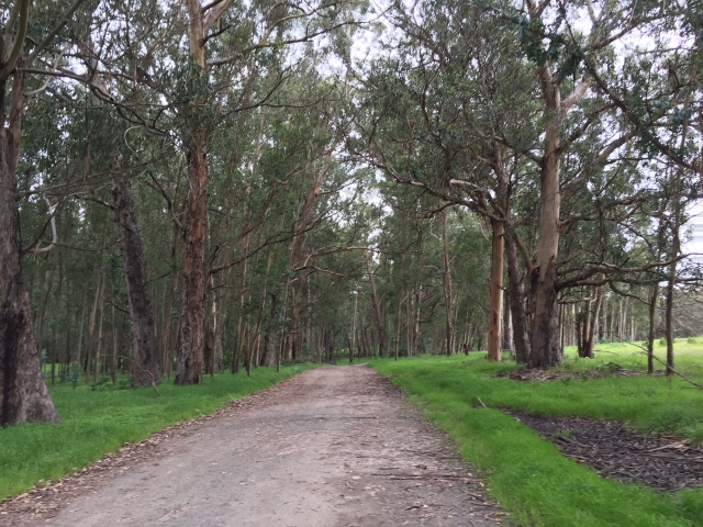
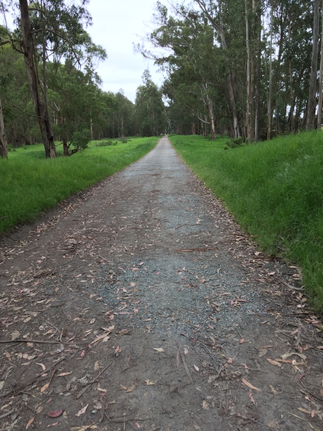
Hiking through eucalyptus on the Bay View TrailLooking towards Mt. Tamalpais
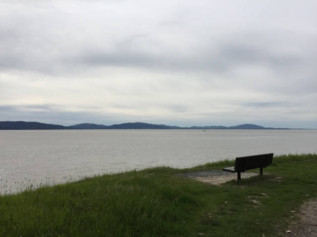
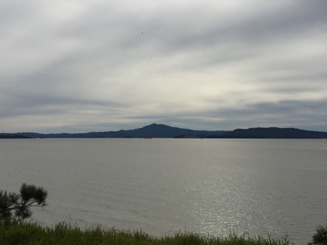
As you continue to follow the Bay View Trail, it will wind in and out of eucalyptus stands, giving great views of San Pablo Bay and Mt. Tamalpais beyond. As you hike out closer to the point, the cliff down to the water grows steeper (though you’ll never be climbing much). It’s about 2 miles of hiking to reach the pier at the end of the point.
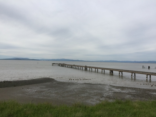
Fishing pier at the end of the point.
From here, follow the paved road south past the bathrooms and pick up the Owl Alley Trail heading south.
Owl Alley Trail is completely flat and straight, entering in and out of eucalyptus forests and grassland. When I visited in spring, the grasses were green and the wildflowers in bloom. Despite the lack of terrain it was quite a pretty scene. Follow this trail all the way to its end, then turn right onto the Cooks Point Trail. You’ll pass by the new entrance to Point Pinole, which hadn’t opened at the time I visited. Look for the Station Trail shortly after the new entrance, and make a left. This trail will take you back to the pedestrian bridge, where you can retrace your steps back to the parking lot. I found Point Pinole to be an enjoyable afternoon hike when the weather wasn’t too warm. I recommend a cool spring or summer evening, when the breezes are blowing off the bay.
Hike Stats
Distance: 3.94 miles
Time: 1-2 hours
Elevation gain: 200 feet
Fees: Parking is $3 when the kiosk is staffed. When it’s not, entrance is free.
Directions: From I-80, take the Richmond Parkway exit, head west. Turn right onto Atlas Road, then turn left onto Giant Highway. The park will be on the right just past the county detention facility.
Park map from the East Bay Regional Park District can be found here.
Angel Island sits in the middle of San Francisco Bay, just off the Marin County coast. As you might imagine, it’s position in the bay affords those who visit world class views of nearly the entire Bay Area. San Francisco, Oakland, Marin County, and much of the East Bay are visible from the island, plus three bridges: the Golden Gate Bridge, Bay Bridge, and Richmond Bridge. Mt. Tamalpais looms large to the north, while Mt. Diablo is visible to the east. Sound great? It is! The only catch is that Angel Island must be timed correctly, or else the views will be shrouded in fog. The day that I picked was near picture perfect, so naturally I felt it was finally time to visit this island that had been on my radar.
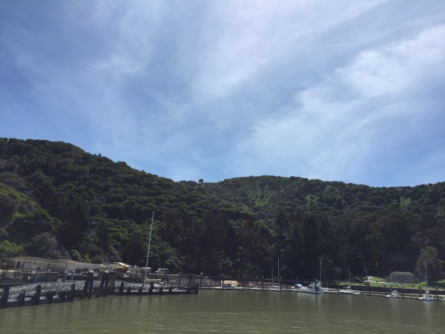
Pulling into Ayala Cove on the ferry from Tiburon
Getting to Angel Island requires a bit of planning. First, it’s necessary to take a ferry to the island. Year-round ferries run from Tiburon in Marin County, or from San Francisco. Seasonally in the summer, ferries also run from Vallejo and Oakland/Alameda. I opted for the Tiburon ferry as it’s more convenient to me coming from the North Bay. The schedule varies by day and month so be sure to check it before heading out. I paid $15 for a round trip ticket and that included my park admission. Not a bad deal if you ask me. The ferry ride was short, only about 15 minutes, and very smooth. In no time we had pulled up to the dock at Ayala Cove, the main dock for all ferries to the island. After disembarking and having a quick lunch, I headed out for the island’s interior.
There are two main hikes that most people do on Angel Island. The first is walking (or biking) the paved Perimeter Trail that circles the island. It’s around 5 miles around and allows you to see all of the sights (and views) of Angel Island. You can visit a building that at one time was an immigration station for boats arriving from Asia. There are also several old military batteries dating back to when Angel Island was a military outpost. Plus you get all of the same views of the Bay Area mentioned above. Since the trail is mostly flat, this would be a good hike for someone who doesn’t want anything too difficult or uphill. I do not prefer to hike on pavement, so I opted for the second main hike that goes into the island’s interior and reaches the summit of Mt. Livermore, Angel Island’s highest point at 788 feet.
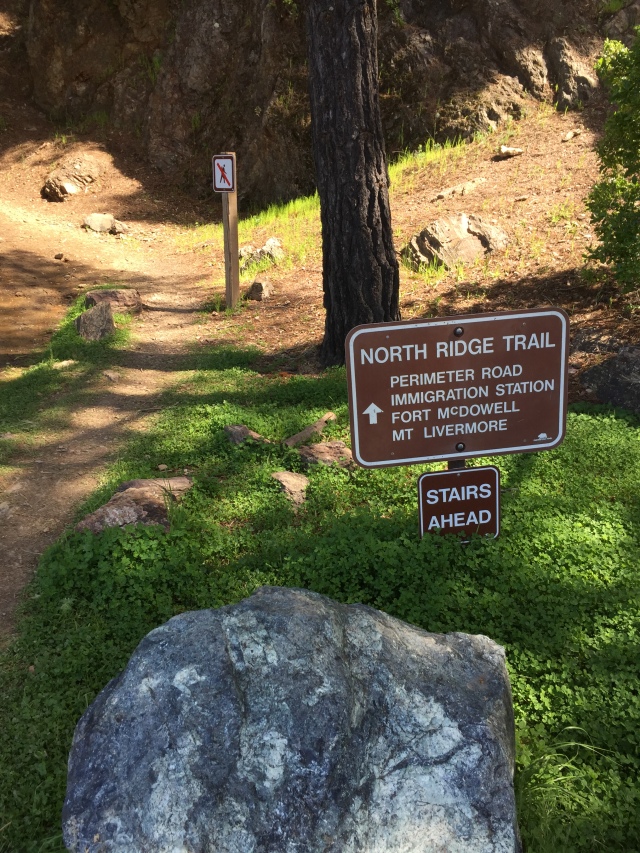
Look for the North Ridge Trail as you exit the ferry
To do this hike, head to the left as you exit the ferry away from the information kiosks and bathrooms. There a small dirt trail heads uphill signed as the North Ridge Trail. The trail heads uphill at a moderate grade and climbs a steep, but relatively short set of stairs. After huffing and puffing up the stairs the trail dumps you out onto the Perimeter Road. Cross the road and pick up the North Ridge Trail on the other side. Now, the trail climbs at a much more gentle grade and does so for much of the remainder of the hike. The trail winds its way up the north ridge of the island looping in and out of shade with spectacular views at every turn.
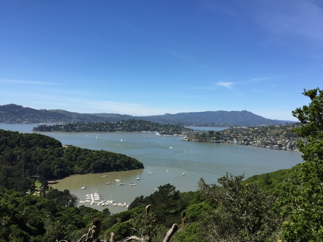
Looking back down to Ayala Cove with Tiburon and Belvedere beyond it and Mt. Tamalpais looming in the background.
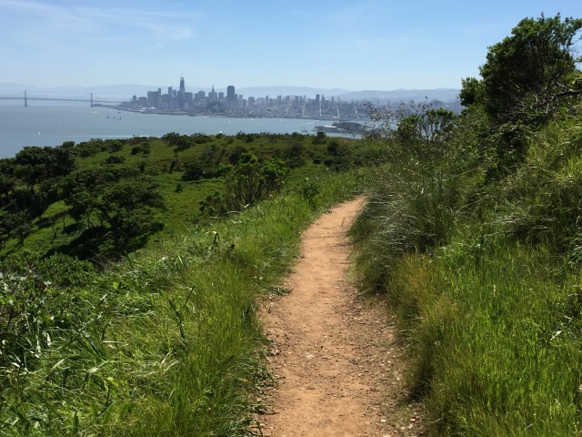
First, Mt. Tamalpais and the Marin coastline appears. Then, the Richmond bridge comes next, followed by the East Bay hills, Berkeley, and Oakland. The best part about this hike is that the view changes at every turn, and every bit of it is spectacular. Continue to follow the North Ridge Trail past the gravel fire road and deeper into the interior of the island. Once you get closer to the summit of Mt. Livermore, the forest will start to thin. After 2.5 miles of hiking, the short spur to the top of Mt. Livermore branches off to the right. Follow this short trail up to the top. Once there, the entire Bay Area unfolds before you and some of the first great views of San Francisco and the Golden Gate Bridge appear.
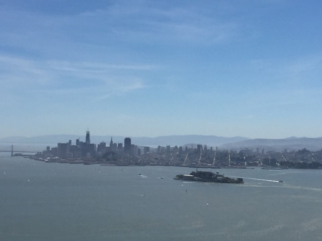
San Francisco looks close enough to touch from the summit of Mt. Livermore
I spent several minutes at the top admiring the spectacular vista. San Francisco looks close enough to touch, and several local mountains and landmarks are visible from up there. It’s amazing to think that the highest point on Angel Island is only 788 feet, but its location in the middle of the bay affords it million dollar views. After I’d had my fill of views (and pictures), I made my way back down the spur trail back to the junction with the North Ridge Trail. This time, turn right onto the Sunset Trail.
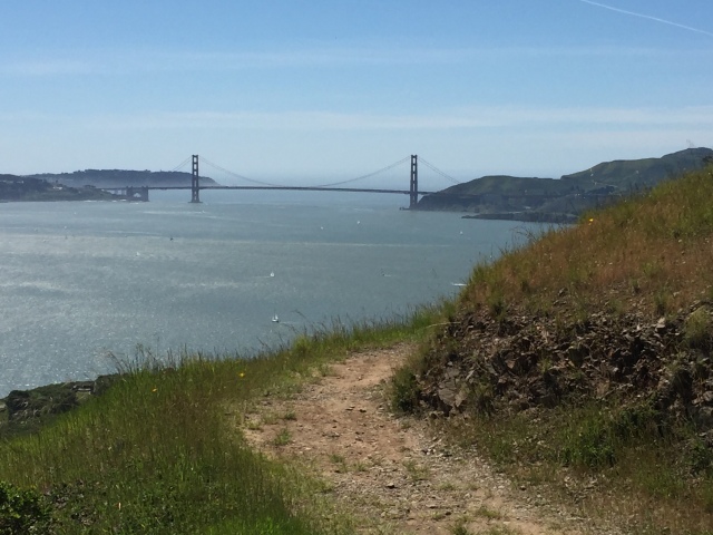
The Sunset Trail offers unobstructed views of the Golden Gate Bridge and San Francisco
The Sunset Trail takes on a whole different character than the North Ridge Trail. For one, the trail traverses the much less vegetated south and west side of the island. This lack of vegetation allows for constant views of San Francisco and the Golden Gate Bridge as you wind your way down the ridge. As if you weren’t thinking it before, trails like this only serve as a wonderful reminder of how lucky we are to live in such a beautiful region. Eventually though, the trail will dip back into forest and switchback its way back down to Ayala Cove and the ferry dock. I had some time to kill to I went to the visitor’s center/museum and read up on some of the history of the island. Check it out if you want to hear about Angel Island’s storied past. Eventually I grabbed the ferry and enjoyed the smooth, but crowded boat back to Tiburon. Bottom line: if you can time the weather right, Angel Island is a not to be missed hike. This might be on my top list of favorite hikes in the Bay Area.
Trip Stats
Distance: 5.5 miles
Time: 2-3 hours
Elevation gain: 800 feet
Fees: Park entrance is included in the round-trip ferry tickets. From Tiburon, I paid $15 round-trip.
Directions: Take the ferry from either Tiburon or San Francisco. Tiburon Ferry Terminal is located at the end of Highway 131 from US-101 in downtown Tiburon.
Park map from the California State Parks can be found here.
Hi all! Sorry about the lack of posts over the last few months….I guess that’s what happens when life gets in the way. However, I wanted to say that it’s been an EXCELLENT spring out on the trails of Northern California! I’ve spent many Saturdays in some of NorCal’s most spectacular spots and can’t wait to share them all with you. I’ve been writing posts on my computer as I went along, and now plan to slowly post them all with the pictures I took. I’ve got lots to share with all of you and hope to be all caught up soon. Also coming soon will be a Facebook page for the blog and perhaps a name change! What will it be? I guess we’ll have to wait and see…. 🙂
This is when you know it’s getting serious…the coffee comes out